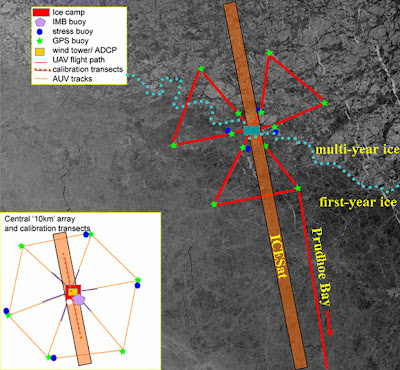
In the first few days, everybody at the camp (and also those people supporting them elsewhere) has been very busy. 6 more local GPS buoys were deployed (with the help of a helicopter) across an active boundary, to give some small-scale ground truth to compare to SAR satellite imagery (synthetic aperture radar). Stress buoys were deployed. Snow measurements were initiated (six 1 km transects). The picture above is a summary of the ideal measurement configuration; the two pictures below are week-old satellite image analyses of the ice camp environments regarding leads (open cracks in the sea ice) and other similar features and dimensions. Keep in mind that two degrees of latitude corresponds to 220 km (140 mi), and two degrees of longitude are ... well, that depends on the latitude you are looking at. I would say 65 km (40 mi) at 73 degrees North.


It is curious that generally speaking, the air temperatures observed at the camp are quite balmy, more corresponding to a good old cold snap in Vermont. As the heaters inside the huts are designed for much colder temps, apparently drastic measures like vents in the roof were necessary. All right, as long as all that doesn't mean accelerated melting underneath them this Spring ...

 2
2 10
10
No comments:
Post a Comment